 The last time I wrote about a famous coastal highway, it was the road that headed up the eastern coast. This month, I want to take you on a journey down the left coast. Pacific Coast Highway (PCH) is a 1,700-mile route that travels along the western coast of the United States, tracing the coastal areas of Washington, Oregon, and California. A combination of US Route 101 and California’s Highway 1, PCH may be one of the most scenic drives in the world as it takes you through lush parks, redwood forests, rugged coastline, and hundreds of quaint and historic towns and beaches along the way. Last time we went from south to north, so this time we will follow the route from north to south.
Our journey along the Pacific Ocean starts inland, in Olympia, Washington, where US Route 101 begins. At first, the highway heads north, toward the lumber town of Shelton, located on one of the southernmost inlets of Puget Sound. A little over 100 miles into the trip north, you will roll into Sequim, WA. From there, the road begins heading west along the northern edge of Olympic National Park. Nearly reaching the most northwestern tip of the Olympic Peninsula, the road finally turns south and heads down the coast. Traveling through Washington, there are not many landmarks – but there are a lot of small logging towns and trees.
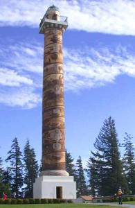
Once you hit the Columbia River and cross the 14-mile-long Astoria-Megler Bridge, you will find yourself in Astoria, Oregon. Founded just after the Lewis and Clark expedition in 1811, Astoria is known for its architecture 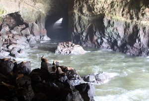 and historic sites. As the oldest American settlement west of the Rockies, there are more historical points of interest here than any other place on the Oregon Coast. One of those points of interest is the famous (and odd) Astoria Column – a concrete and steel tower overlooking the mouth of the Columbia River on Coxcomb Hill (see photo). The 125-foot tall tower was built in 1926 and has a spiral staircase inside that ascends to an incredible observation deck.
Heading south from Astoria, US Route 101 hugs the Oregon coast for the entire length of the state. Along the way, you will find all sorts of beach towns, bridges, parks, scenic turnouts and historical markers. Our first stop is the Fort Clatsop National Memorial, the site where the Lewis and Clark Expedition spent the winter of 1805-06 (a replica of the original fort is there now). A little further south you will find Cannon Beach, where an actual cannon washed ashore in 1846 after a Navy schooner was wrecked. There is a replica of the cannon and a historical marker just south of town, but you can find the original at the Heritage Museum in Cannon Beach.
 Devil’s Churn, just south of the seaside town of Yachats, is a photographer’s dream. This ocean inlet was created over thousands of years as waves carved into the rocky shoreline, forming a sea cave whose roof eventually collapsed. As the tide comes in, it can throw water spray several hundred feet into the air when the waves reach the end of the churn. Not far from there, you will find the Sea Lion Caves, a tourist stop where you can pay to take an elevator deep down the ocean cliff wall into a cave to observe hundreds of sea lions hanging out (see photo). It is a pretty cool place, but one word of caution – it really stinks down there!
Just a few minutes south of Florence is Honeyman State Park. Open year-round, this park has three Lakes and extensive camping facilities. Adjoining the park, the Oregon Dunes are a unique area of windswept sand that is the result of millions of years of wind, sun, and rain erosion. These are the largest expanse of coastal sand dunes in North America, and they provide numerous recreational opportunities including off-road vehicle use, hiking, fishing, canoeing, horseback riding and camping.
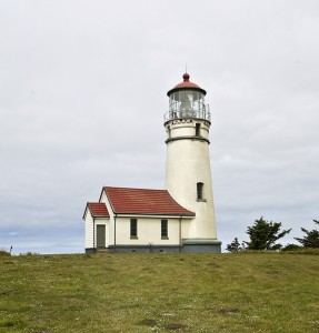
The Cape Blanco Lighthouse (see photo), built in 1870, is located at the westernmost point in Oregon. Near the lighthouse, you will also find the Victorian-style Patrick Hughes House, which was built in 1898 (see photo). The hard-working Hughes family operated a 2,000-acre dairy here, and their beautiful home has marvelous 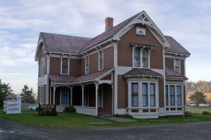 views of the lighthouse. A little further south, you can see dinosaurs at the Prehistoric Gardens in Port Orford. For 40 years, sculptor E.V. Nelson built dinosaurs, then later decided to make it a tourist destination. His 23 life-sized dino replicas are “scientifically correct” but it is their unique coloring that you will remember.
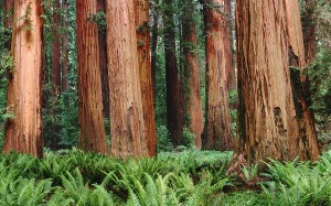
After crossing the border into California and passing through Crescent City, you will find yourself amongst the majestic Redwoods (see photo). This beautiful area includes Redwood National Park and California’s Del Norte Coast, Jedediah Smith, and Prairie Creek Redwoods State Parks. Covering 133,000 acres, the four parks, together, protect 45% of the remaining coastal redwood old-growth forests (these are the tallest trees on Earth). In addition to the redwood forests, the parks also feature vast prairies, oak woodlands, wild river ways, and nearly 40 miles of pristine coastline. I’ve only been there once, but it was well worth the trip. If it’s not already on your bucket list of places to visit, I would add it, for sure.
 Continuing south on US Route 101, after passing through Eureka and more redwoods, you come to the small town of Leggett. Here, we will exit US Route 101 and begin traveling on Highway 1, which is a scenic 225-mile portion of the road that takes you along the coast through Fort Bragg, Anchor Bay, and Bodega Bay before reaching the Golden Gate Bridge. Crossing the bridge into San Francisco and then continuing south on Highway 1, you’ll find some of the most beautiful homes along this part of the route.
Traveling along the coastline south of San Francisco, you will eventually find yourself in Santa Cruz. This surfer town sits at the top of Monterey Bay and features, among other things, the Santa Cruz Beach Boardwalk – a classic seaside amusement park with over 34 rides and attractions, including two National Historic Landmarks: the 1924 “Giant Dipper” wooden roller coaster and the 1911 Looff Carousel. Driving south around the bay, you pass through the old town of Seaside (founded in 1887) and then end up in the city of Monterey, which is home to the amazing and educational Monterey Bay Aquarium. Once you pass through Monterey, the road gets really interesting.
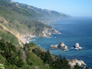 South of Monterey, en route to San Luis Obispo through Carmel, Big Sur, San Simeon and Cambria, is a 135-mile stretch of what is arguably one of the most picturesque coastlines in the United States (see photo). Make sure your gas tank is full and be prepared, because that piece of PCH could take you the better part of a day to complete if you stop and take a lot of pictures and enjoy all the sights along the way. Construction on this segment of the highway began in 1919. Utilizing prison labor from San Quentin Prison, inmates were paid 35 cents a day and had their sentences reduced for their hard work along the Big Sur coastline. In San Simeon, high up in the Santa Lucia Mountains, the huge 115-room Hearst Castle overlooks the ocean. Construction of the mansion began in 1919, the same year as Highway 1, and ironically, it cost as much to build as the highway. With the aid of New Deal funds, the paved two-lane road was completed 18 years later in 1937. In 1965, the section of the road along the Big Sur coast was declared the first State Scenic Highway.
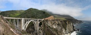
One of the most photographed landmarks along this portion of the highway is the Bixby Creek Bridge near Big Sur (see photo). The iconic bridge, with its two towers below the roadway and a concrete arch spanning between them over the canyon, was built under budget for just $200,000 in 1932. At the time, it was the longest concrete arch span (320 feet) on any road in California. Today, after a $20 million
seismic retrofit in 2000, it is still one of the tallest single-span concrete bridges in the world.
 Once you arrive in San Luis Obispo, you merge back on to US Route 101 and continue on through Pismo Beach, Santa Maria, Santa Barbara, and then Ventura. In Oxnard, you again exit the 101 and get back on Highway 1. From there, you travel south along the coast to Malibu, where many actors, musicians, athletes and business executives live in beautiful beach houses. During the 1932 Summer Olympics, this segment of Highway 1 also hosted part of the road cycling events. This portion of the road is also famous for mudslides, which sometimes cause parts of the road to be closed for months at a time, but road crews work quickly to clear the busy route as soon as possible.
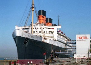
Once you get through Malibu, things get very busy and congested as you arrive in Santa Monica and then continue south through all of the popular beach communities in Los Angeles like Manhattan Beach, Hermosa Beach, and Redondo Beach. After that, you get to Long Beach, home of the permanently-docked Queen Mary ship. Once the grandest ocean liner in the world, the Queen Mary is now a full-service hotel, historical landmark, and entertainment venue (see photo). The Queen Mary gives visitors a unique glimpse into a bygone era when steamships were the most regal way to travel.
 Continuing south, you cross into Orange County and pass through the popular beach towns of Huntington Beach (the home of 10-4 Magazine), Newport Beach, and Laguna Beach. Originally built around 1888, Hotel Laguna was the first hotel and substantial business building in Laguna Beach. It is picturesque, romantic, and has quite an intriguing past. In 1928, the hotel was demolished on speculation that its bat and board construction was a fire hazard. The new building, which was dedicated in 1930, is the hotel that still stands today.
As we end our 1,700-mile journey in Dana Point, California, Highway 1 comes to an end at Interstate 5. From there, you can continue along the coast down through San Diego and on to the Mexican border, but most people would not consider I-5 as part of PCH. Years ago, it was common for adventurous travelers to hitchhike the route, but I would not recommend doing that today. But those who did it back then, probably have some great stories to tell. Because of its twists, turns, hills, and gorgeous scenery, PCH is also one of the most desirable routes in the United States for motorcyclists to ride.
Even if you can’t make it to the west coast to take a trip up or down this scenic route, I urge you to do a search on the internet of the places mentioned in this article and enjoy the pictures and stories you find of this unique and beautiful highway. And, if you are lucky enough to one day take a cruise up or down Pacific Coast Highway, be sure to slow down, savor the scenery, and stop to take lots of pictures!
